Skip to content

KAI Water & Energy · your remote co-workerWater and energy, foreseen.

The modelling team you don't have to fly in. We build live models of your aquifers, rivers, industrial park, reservoir or deep subsurface from your own data, and deliver them to your workspace wherever you are, in a browser, with us on call.

Water
  • Site boreholes and map aquifers in 3D
  • Run an industrial park's water and compliance
  • Forecast floods, and set parametric triggers insurers can price
Energy
  • Plan hydropower releases from the inflow forecast
  • Carry rock properties from the core plug to the reservoir
  • Model geothermal, CO₂ and hydrogen storage sites
Latest
The platform

One platform for water and energy

Rivers, aquifers and rocks feed both. KAI models them with one engine, on one account, so a forecast built for a flood warning can also plan a hydropower release.

How we work

Your remote co-worker in water, geoenergy and anticipatory action

We bring the solution to your workspace, however many miles away you are. No consultants to fly in, no software to install: your team keeps working the way it does, and the models come to you.

  1. Share what you have

    Borehole records, well logs, meter exports, lab results, river levels or a link to your system. A private workspace is set up on day one.

  2. We build the model

    Process-based models of groundwater, rivers, sewers, reservoirs or the deep subsurface, checked against your measurements, with the uncertainty stated.

  3. It arrives in your workspace

    A live model in the browser, alerts by email and phone, a short report and files for your GIS or your own software. One KAI login.

  4. We stay on call

    We review the results with you online, update the model as new data arrive, and answer within two working days.

No travel or site visit needed to startNo installs or licencesYour data stays yoursFixed scope and price

Own it, run it, we back it

Your own KAI workspace

Create an account, customise the product to your operation and own it for daily work. KAI runs everything behind it: storage and database, the knowledge base, and the software that schedules and runs your model jobs. The front end is yours from day one.

You runDashboards · maps · alerts · reports · your users
KAI runsDatabase and storageKnowledge baseJob and workflow orchestration
KAI engineCalibrated models for water and energy, tested on real data
One account for every KAI product. Free to start.
  • Your account, your product

    Open a free account, pick the product and switch it on. Your sites, users, thresholds and layers are set up for you, and the front end is ready the same day.

  • Customised, then yours to run

    We shape the product to your operation: the points you watch, the reports you file, the alerts your team needs. Your team runs it every day; your data stays yours and exports at any time.

  • Storage and database, handled

    Time series, maps, logs, models and files kept in one managed database, backed up, secured per user and shared only as you decide.

  • A knowledge base that grows

    Your reports, methods, data sources and model documentation in one searchable place, so a new engineer finds why a number is what it is.

  • Workflows that run themselves

    Model runs, data pulls, quality checks and alerts are scheduled and queued for you, every day, with a log of each run.

  • A team on call

    We keep the models calibrated, add data as it arrives and answer within two working days. You get a modelling team without hiring one.

Solutions

From the rain cloud to the reservoir

Each solution ends in something you can act on: a depth, a forecast, an alert, a release plan or a model.

Live today

Start free on any of them

Four products live on one account. Start free in the KAI portal and upgrade when it pays.

GroundWater Analyst
For water authorities, drillers, NGOs and farms

GroundWater Analyst

3D groundwater models from borehole records: water table, bedrock, aquifer layers, boreholes and flow, with cross-sections anywhere.

Free plan · paid from $149 per site

HydroSaaS
For industrial parks and factories

HydroSaaS

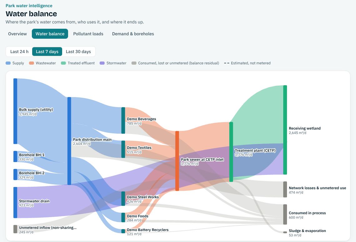
Water balance, pollutant loads and sources, demand and borehole drawdown, and effluent compliance against NEMA limits.

Free plan · paid from $99 per month

KAI-Hydro
For insurers, districts and agencies

KAI-Hydro

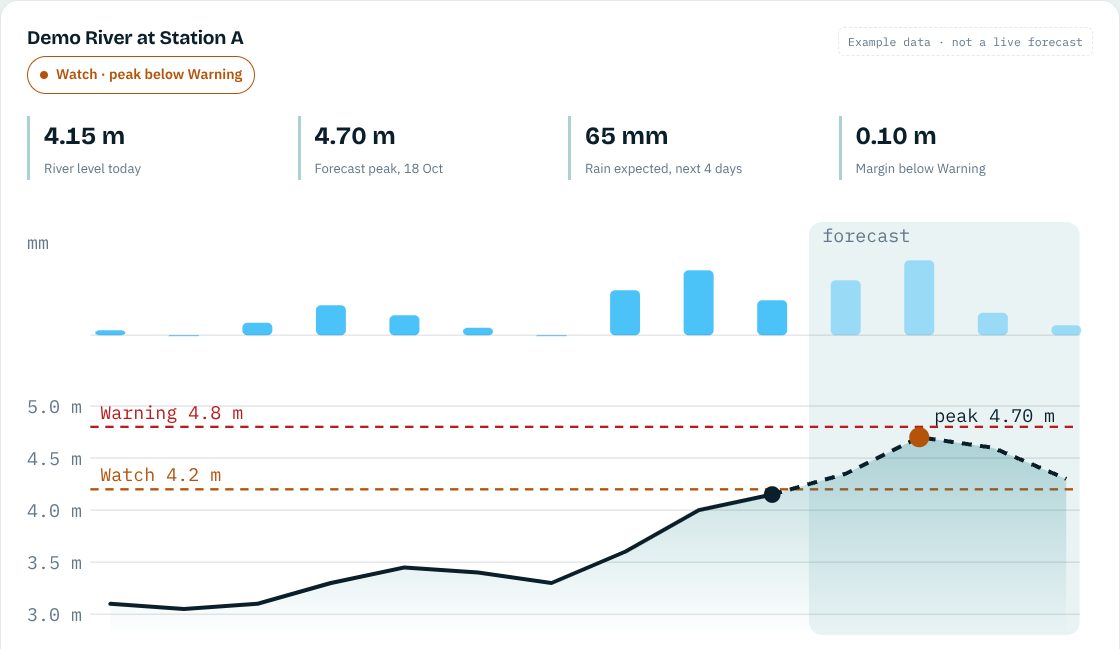
Parametric flood triggers back-tested against river gauges, and daily flood and drought forecasts ending in a plain Normal, Watch or Warning.

Free plan · paid from $190 per month

KAI-Subsurface
For energy operators and consultants

KAI-Subsurface

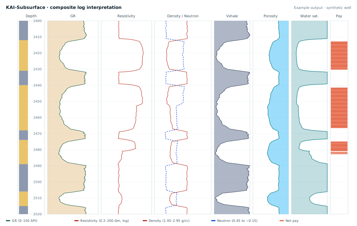
Fixed-price well-log interpretation, geomodels and AI property prediction between wells.

Free plan · paid from $490 per well

New for energy · early access

Hydropower reservoir management

Every hydropower reservoir walks a line between spilling water it could have turned into power and running too low to meet demand. KAI-Hydropower forecasts the inflow, projects the level and the energy for each release plan, and warns days before either happens.

  • Daily inflow forecasts from calibrated basin models
  • Level and energy projected for each release plan you test
  • Spill and low-level warnings days ahead
  • One forecast for every plant on a cascade
Reservoir level forecast for two release plans Illustration. The observed level rises towards today. With the current release the forecast crosses the full supply level in about 19 days, so the reservoir would spill. With a 20 percent higher release it stays below. Spill: water lost to powerFull supply level Minimum operating levelGeneration cut Today30 days agoin 30 days Spill forecast in 19 days +20 % release: no spill
Observed levelCurrent releaseRelease 20 % higherIllustration with made-up numbers
In development

Built one by one, open early to you

Join any of them free from the KAI portal. Early-access members hear first and get an introductory price.

Energy

KAI-Hydropower

Reservoir inflow forecasts and release planning for hydropower

Join early access →
Ground

KAI-Geotech

Geotechnical site data and accredited lab sourcing

Join early access →
Energy

KAI-GeoEnergyLive preview

Geothermal, CO₂ and hydrogen storage models

Try the live preview →
Water

KAI-River

River surveys, rating curves and hydraulic models

Join early access →
Ground

KAI-Twin

Digital twins of basins, wellfields and networks

Join early access →
Water

KAI-Irrigation

Water availability and irrigation scheduling

Join early access →
Why KAI

What's unique in KAI

Working models, not pictures

Every product runs a model you can turn, question and download.

Free to start

Every product has a free tier. Pay when it pays for itself.

Delivered to your workspace

We work remotely, inside your workflow. A phone or laptop is enough.

One login, water and energy

Every KAI product on one account, with new ones added as they launch.

Honest about uncertainty

Methods stated and uncertainty shown in every result.

Clear contracts

Fixed scope, invoices you can plan for, delivery on time.

GroundWater Analyst · central cattle corridor
The full GroundWater Analyst model of the cattle corridor
Case study

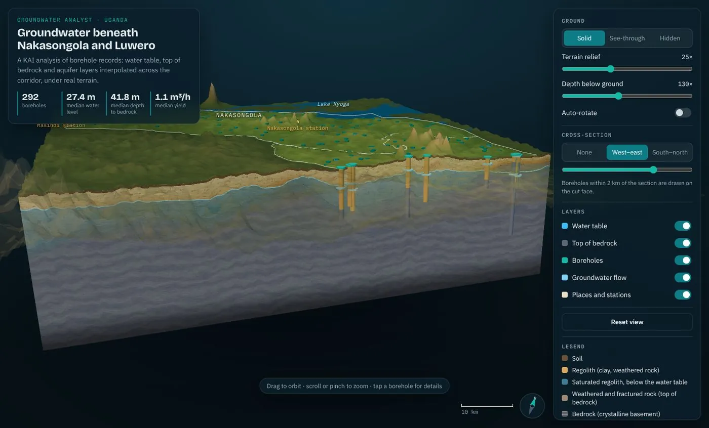
Groundwater beneath Nakasongola and Luwero

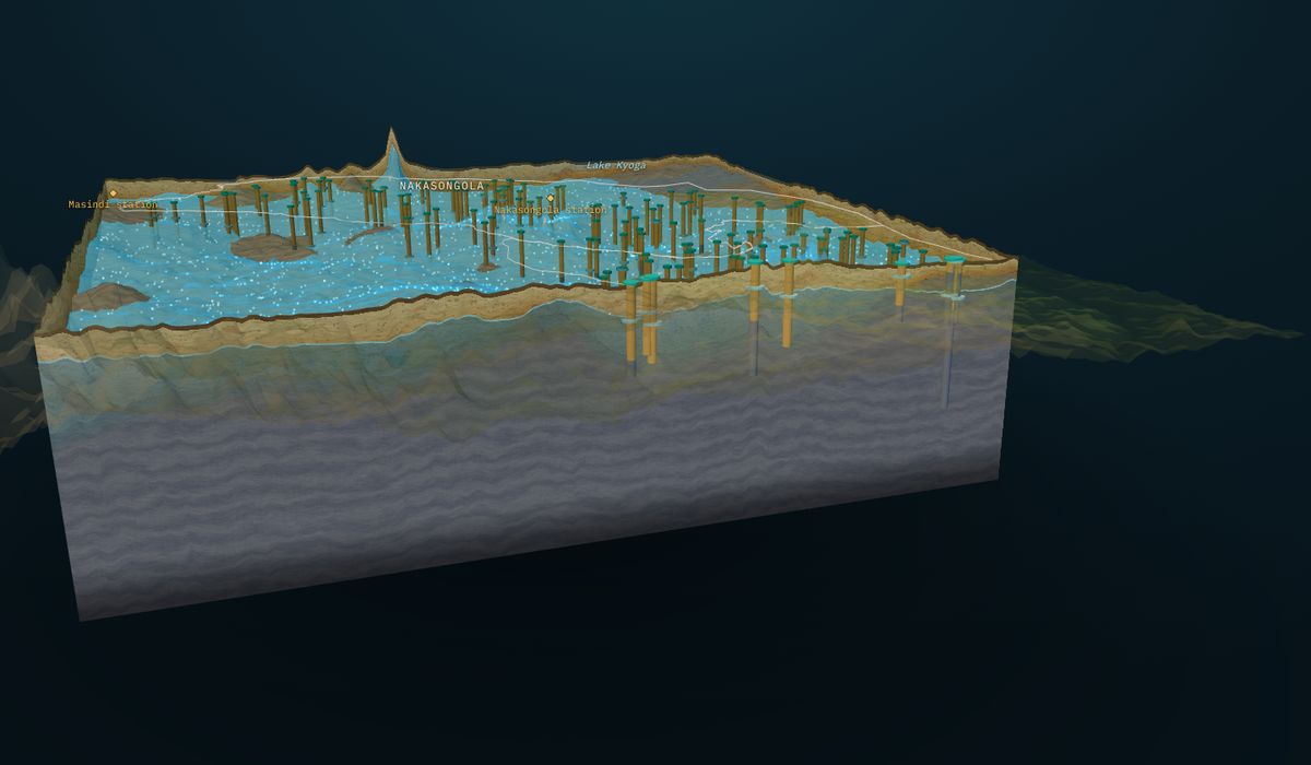
GroundWater Analyst at work in Uganda's cattle corridor: a 3D aquifer model with 292 boreholes. It shows water about 27 m down and bedrock about 42 m, so most boreholes draw from a thin saturated band. The same model now covers the south-west cattle corridor and the Aswa catchment, read from 387 drilling logs.

Now published: an open book chapter on groundwater across the whole cattle corridor, from 7,306 boreholes and 18 monitoring stations, with drought triggers. Read it on Zenodo ↗

New · GroundWater Analyst · free demo, no sign-in

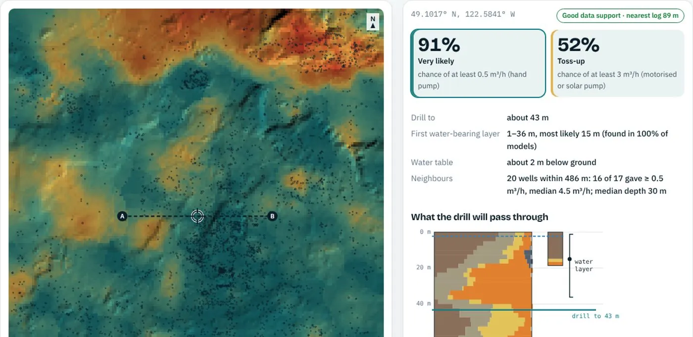
If you drill here, what are the odds of enough water?

The KAI Heterogeneity Lab reads every driller's log around a site and answers the questions a drilling budget depends on. Try it on 4,288 public well records; then run it on your own boreholes.

KAI Heterogeneity Lab: map of the chance of enough water, with the site answer and the ground down the holeHeterogeneity Lab · drilling odds · tested blindTap a site, get the drilling answerThe chance of at least 0.5 m³/h (hand pump) or 3 m³/h (motorised pump), the depth to the first water-bearing layer, how deep to drill and what the drill will pass through, from the ground models between wells. Tested on 595 wells it never saw: it ranks wet and dry sites with an AUC of 0.83, and its stated chances match what happened.Open the demo →   Run it on your boreholes (sign in) →
Plans

Free to start, priced to grow

Every product has the same four tiers. One login, one invoice.

01

Free

Explore the models, demos and a first check. No card, no invoice.

02

Starter

One site, one factory or one river point, delivered fast.

03

Professional

Your own private model, park or forecast network, kept current.

04

Premium

Programmes, integrations, a named expert and a service-level agreement.

Get started

Start with one site, one park or one reservoir

Open a free account, or book a 30-minute demo on your own area, park, river or reservoir.